.png)
 1 month ago
25
1 month ago
25
 Image source, Reuters
ByDarren Bett
Lead Weather Presenter
Hurricane Gabrielle is only the second major hurricane of the Atlantic hurricane season, forming less than a week ago in the mid tropical Atlantic.
It rapidly intensified near Bermuda but after a sharp turn to the right it is now heading back across the Atlantic towards the Azores.
Whilst Gabrielle will weaken as it travels over cooler waters, parts of western Europe are still likely to be hit by severe weather.
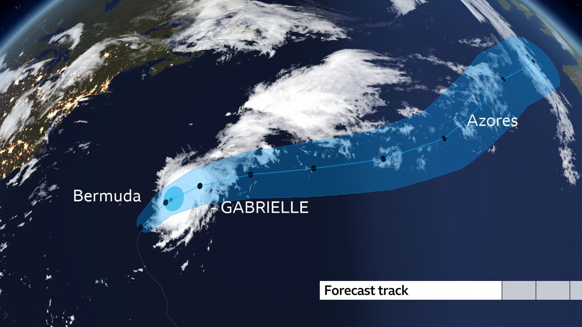 Image source, BBCWeather
Hurricane Gabrielle is forecast to leave Bermuda and head to the Azores
Hurricane Gabrielle
So far this season there have been more tropical storms and hurricanes in the east Pacific than the Atlantic basin. The Atlantic hurricane season has been quiet for multiple reasons but we are now in the peak period of hurricane activity.
Gabrielle strengthened on Monday to become a major hurricane near Bermuda. Early on Monday it was still a category 4 hurricane with sustained winds over 135mph (217km/h).
According to the National Hurricane Center the hurricane appears to have reached peak intensity. The eye of the hurricane is less distinct, probably as a result of vertical wind shear. Wind shear tends to weaken and ultimately rip hurricanes apart.
Gabrielle is forecast to be steered to the north of the sub-tropical ridge of high pressure then accelerate as it is picked up in a stronger westerly wind-flow.
Increasing shear and cooler water should cause Gabrielle to weaken faster.
However, Gabrielle is still expected to be a hurricane as it approaches the Azores later on Thursday. Biggest impacts here could come from large waves forecast to be 5-6m high.
From there the remnants of Hurricane Gabrielle will race on to mainland Europe.
Heavy rain on the way for Portugal
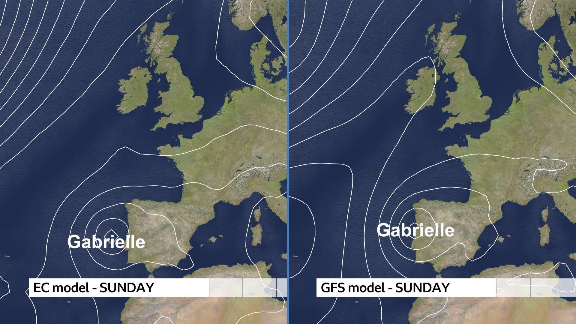 Image source, BBCWeather
Computer models now predict an area of low pressure in a similar place
Predicting where a hurricane can hit five days or so ahead can be very difficult.
Hurricanes throw a huge amount of energy and heat into the atmosphere and when they head over the Atlantic they disrupt the jet stream pattern. This is something that historically all computer models have difficulty with which leads to a greater level of uncertainty.
Climate change could possibly add to the uncertainty with hurricanes expected to become more powerful, slow down and rapidly intensify more often.
Having said all that, the main computer models are now showing much more agreement.
Both the EC and GFS forecasts show an area of low pressure (the remains of Gabrielle) hitting Portugal on Sunday. A combination of large waves, strong winds and heavy rain is likely to bring some disruption here.
Will Gabrielle impact the UK?
It looks like we are going to be spared the wet and windy weather from Gabrielle.
An area of high pressure is keeping the UK dry this week and after some chilly nights it will become milder.
A band of rain will push in from the west on Friday night and Saturday but the rain will tend to die out on Sunday and many eastern parts of the UK look like staying dry.
Stay up to date with how long the dry weather will last and any changes to the forecast track of Gabrielle this weekend on the BBC weather app.